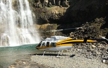
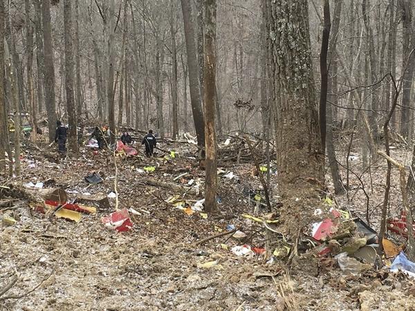
On Jan. 29, 2019, a Bell 407 helicopter air ambulance operated by Survival Flight crashed near Zaleski, Ohio, killing the pilot, Jennifer Topper, and flight nurses Bradley Haynes and Rachel Cunningham.
In May of this year, the National Transportation Safety Board (NTSB) ruled that the probable cause of the accident was Survival Flight’s “inadequate management of safety,” which led to the pilot’s inadvertent encounter with instrument meteorological conditions (IMC). The NTSB was unable to determine whether Topper experienced spatial disorientation and lost control of the aircraft, or performed controlled flight into terrain.
Although the NTSB’s main focus was on the lack of proper safety procedures and protocols by Survival Flight, the board also made some more general recommendations dealing with weather radar. Here, we take a closer look at those recommendations and their implications for helicopter pilots.
To start with, the United States is covered by a network of weather radars known as NEXRAD. The NEXRAD network consists of 157 sites in the U.S. Most of these are operated by the National Weather Service (NWS). Some are under the Department of Defense. And sites in Alaska and Hawaii are run by the Federal Aviation Administration (FAA).
The radar units themselves are referred to as WSR-88D (for Weather Surveillance Radar 1988 with Doppler capability). These were the NEXT generation of weather radars following the WSR-57 and WSR-74 units. The main purpose of this radar network is to provide the general public with accurate information on precipitation occurrence and movement, especially in terms of severe weather such as thunderstorms.
Radar sites were determined to give maximum areal coverage. Although the aviation industry readily uses this information, the individual sites and the network itself are not specifically designed or located to provide all the needed aviation support.
To address specific aviation requirements, there are also 45 Terminal Doppler Weather Radar (TDWR) units operated by the FAA and located at major metropolitan airports in the U.S. and Puerto Rico. They provide better coverage for the terminals more distant from the nearest NEXRAD site. The Doppler component of these radars was seen as critical in determining dangerous wind shear.
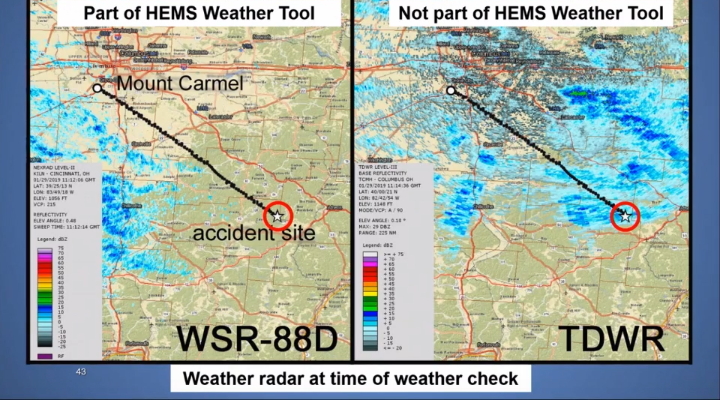
In the case of the Survival Flight accident, the area of IMC, a band of snow, did not show up on the HEMS Weather Tool NEXRAD display that is widely used by the air ambulance industry for flight planning purposes. The band of snow was too far away from the closest NEXRAD site to be detected. In a post analysis, however, investigators discovered that this precipitation had been detected by a nearby TDWR.
Data from TDWR sites is not currently incorporated into the HEMS Weather Tool. Had this data been available at the time of the accident flight, it is possible that a Survival Flight operations control specialist would have more readily recognized the potential for snow along the route and advised the pilot accordingly.
In its response to the accident, the NTSB recommended that the FAA install the latest software on its TDWRs and require the NWS to distribute Level II (digital) TDWR data to all of its users “so they will have access to the most accurate precipitation information.” More specifically, the NTSB asked the NWS to add TDWR data to the HEMS Weather Tool overlay.
Low-level gaps
There was another issue the NTSB considered which is far more complex: the lack of radar coverage especially at lower levels. To address this issue, the NTSB recommended that the NWS “provide capability in the HEMS Weather Tool to graphically display areas of weather radar limitations, including areas where beams may lack low-altitude coverage, areas that lack radar coverage, and areas of beam blockages.”
As the NTSB explained, “areas that lack radar coverage” are simply regions which lie beyond the standard range of the WSR-88D units, typically given as 145 miles (230 kilometers). “Areas of beam blockages” refers to physical obstacles to the radar beam such as topographic features or nearby buildings. This leaves areas that “lack low-altitude coverage.”
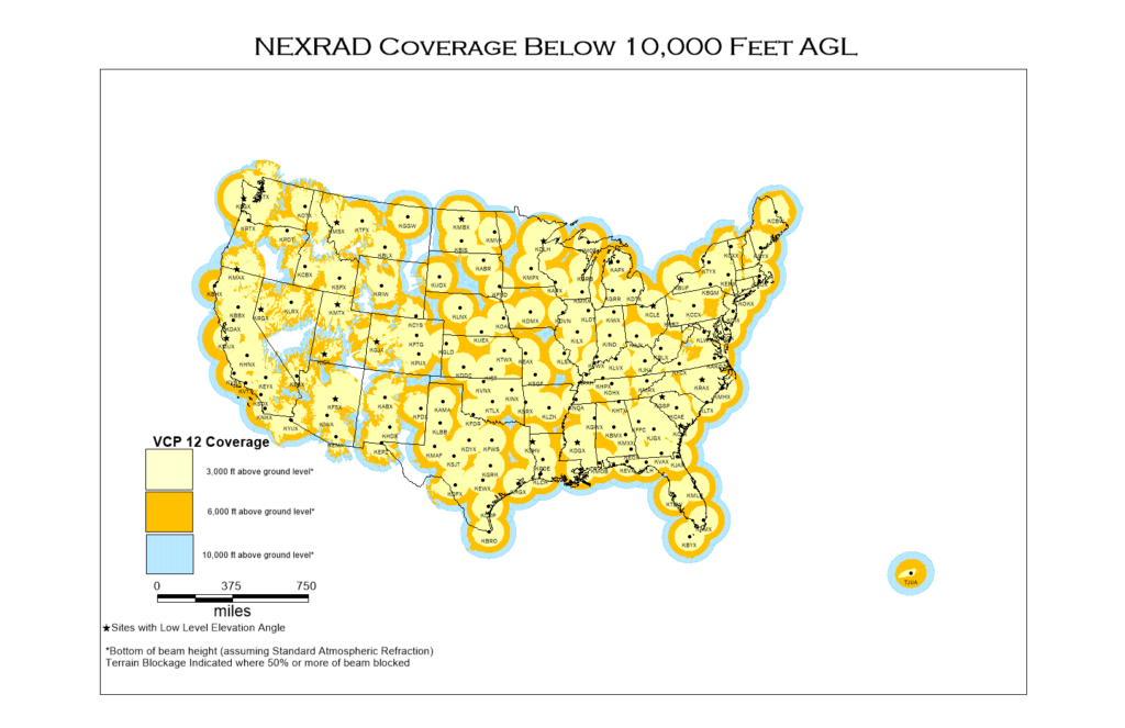
If you look at the standard NEXRAD coverage map, it appears that the continental U.S. is well covered by weather radar. There are only a few areas with no coverage (white on the map) with this mainly due to terrain blockage or sometimes just distance from the nearest radar site. But a closer examination reveals problems, especially for the helicopter industry.
Blue areas on the map only have coverage above 10,000 feet above ground level (AGL), while darker yellow areas show coverage above 6,000 feet AGL. Even the baseline coverage (light yellow) is above 3,000 feet AGL. Of course, many helicopter operations are below this.
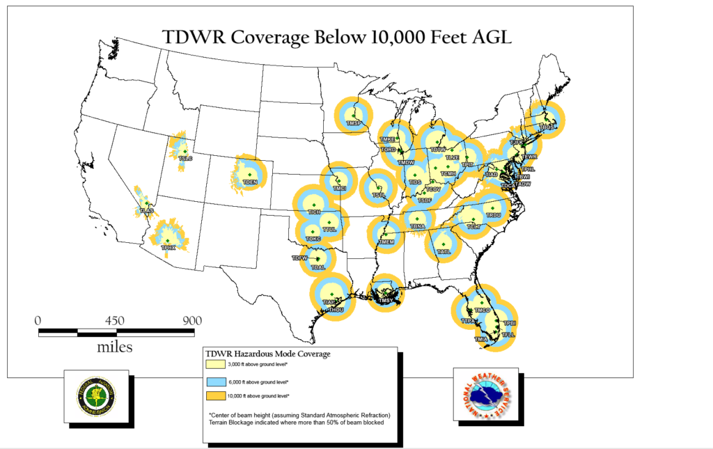
Now, look at the map showing TDWR coverage. Yes, adding TDWR to weather radar overlays would help in some areas, but it certainly won’t provide coverage in the majority of locations where it’s lacking.
The basic problem with low level radar coverage is that the radar beam overshoots low areas of precipitation. To avoid nearby ground clutter (buildings, terrain features, etc.), radar transmitters are aimed up with 0.5 degrees of tilt. Together with the natural curvature of the earth, the radar beam goes higher and higher above the ground as it goes out. Thus, it will often overshoot low, stratiform precipitation.
At 145 miles (230 km), the bottom of the radar beam is at 10,000 feet above the surface. At 100 miles (160 km), the bottom of the radar beam is at 5,000 feet. The bottom of the beam only reaches 3,000 feet at about 80 miles (130 km) from the radar site. Closer than this and coverage gets even lower. So, only within 80-some miles from the site will you get information on precipitation at or below 3,000 feet. Beyond this, if there is no closer adjacent radar site, you have no low-level coverage.
The WSR-88D units can detect convective precipitation, showers and thunderstorms, sometimes out to several hundred miles. The cumulus clouds associated with convective precipitation have great vertical depth and can extend upwards tens of thousands of feet into the atmosphere. Therefore, even when the radar beam is well above the earth’s surface, it can still detect this type of precipitation. This is great for the general public and for fixed-wing aircraft which operate at higher elevations.
The problem in the Survival Flight crash was with stratiform precipitation. Stratiform precipitation is produced by less concentrated and less intense lifting than convective precipitation. Widespread low cloud decks are typically formed which cover large areas but are usually not that deep. Precipitation rates are modest. Stratiform precipitation and cloud areas generate the IMC that is dangerous especially for helicopters. And this is what weather radars can often not detect.
The only true solution to the problem would be to install many more weather radar sites across the country. This is not feasible. In lieu of that, providing helicopter operators with information describing radar coverage or the lack thereof would be most beneficial. In response to the NTSB’s recommendations in the Survival Flight crash, the NWS and the FAA assembled a joint working group “to examine the recommendations and consider how to address them,” with the intention of reporting to the NTSB no later than Oct. 30, 2020. An NWS spokesperson told Vertical on Oct. 23 that there were no updates from the working group yet.
Editor’s note: Learn more about weather radar and its limitations in this article originally published in the February-March 2016 issue of Vertical.