

Sandels updated ST3400H HeliTAWS offering raises the bar in helicopter terrain awareness and warning systems and exposes a need for the industry to update its TAWS standards.
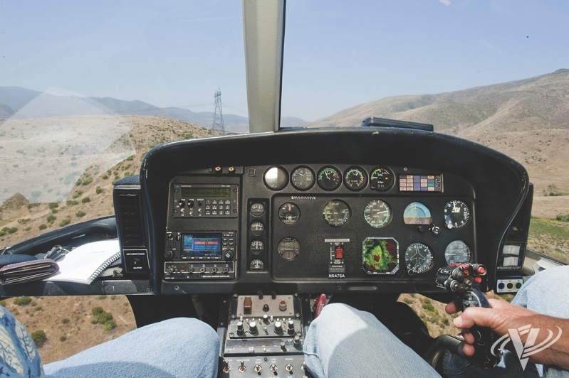
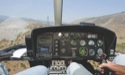
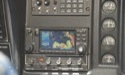
Our evaluation platform: an AS350 configured with a conventional HTAWS (left) and Sandel’s new ST3400H HeliTAWS. Note, on the unit on the left the terrain data is completely obscured with a visual terrain warning that’s accompanied by an audible alert. The Sandel unit, on the other hand, continues to display terrain data and so much more.

I marvel at todays technology. It boggles my mind to consider the advances that have taken place and the innovative products that have come to market in recent years. Today, we have capabilities at our fingertips that not long ago seemed to exist only in science fiction.
Having spent nearly 20 years flying for one of Southern Californias largest public safety agencies, I can remember occasions when I resisted suggestions to incorporate some of the early versions of those new technologies such as helicopter terrain awareness and warning systems (HTAWS) just because they were so new. While they may have been advertised as the latest and greatest, I couldnt help but wonder how much benefit they really provided: might these systems fall short of expectations or perhaps adversely affect my ability to accomplish the mission?
Our operations at the time involved day and night/night-vision-goggle visual-flight-rules operations, utilizing a fleet of nine helicopters. Our law enforcement, search and rescue, and firefighting missions covered 4,200 square miles, consisting of rugged terrain from below sea level to over 6,000 feet altitude.
Even with an area of that size and variability, I believed our crews had developed a pretty keen familiarity with the local flying area, including airspace, terrain features, obstructions and wire spans. As a result, I wasnt convinced that a technology like HTAWS would necessarily provide an improvement over good ol situational awareness, head up on a swivel and eyes outside the cockpit.
While TAWS devices had long been in use in the fixed-wing community, many of us wondered if these systems really worked as advertised in helicopters. Did the bells, whistles and functionality really enhance our ability to do the mission, increase safety and improve situational awareness? Or were they largely eye candy, and something that even created a false sense of security or perhaps a distraction in the cockpit? Did these systems originally designed for airplanes and now being repackaged for helicopters have limited application to the unique flight characteristics and missions of rotary-winged aircraft? For many pilots I spoke with back then, it was hard to know what the real answer was, and often we didnt really know until the systems were installed and functioning; and by then it was usually too late.
Putting It to the Test
With all that in mind, in late 2009, when I had an opportunity to conduct a hands-on operational evaluation of Sandel Avionics ST3400H HeliTAWS offering (see p.8, Vertical 911, Heli-Expo 2010), I was very curious, but admittedly a bit pessimistic.
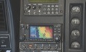
The Sandel ST3400H was (and is) a small, completely self-contained HTAWS computer, specifically designed for helicopters, and loaded with three separate databases containing terrain and human-made obstacle information. The data was rendered via a colorful, three-inch display as super-detailed, graphically depicted, three-arc-second terrain and features. The system, meanwhile, required an interface with a Wide-Area-Augmentation-System-capable GPS in order to obtain the necessary position and altitude information.
Sandel claimed its ST3400H system provided predictive look-ahead warnings by comparing its terrain and obstacle database to position information provided by the GPS or a flight management system navigator. Although it was not intended as a primary navigation device, it was a situational awareness tool, one that remained rather obscure during normal flight operations.
During the nearly two-hour evaluation flight, flying through canyons and among hilly and mountainous terrain, I was fascinated by how the ST3400H seemed to perform exactly as advertised. It displayed real-time, easy-to-interpret, colored, three-dimensional graphical depictions that were accurate representations of the terrain and obstacles that lay ahead and to both sides of my flight path.
I was also relieved to find the unit did not give me inappropriate or unwarranted audible cautions or warnings, a complaint that had been expressed in regards to HTAWS offerings from other manufacturers. Instead, the ST3400Hs visual and audible advisories were appropriate, and sounded only when the unit calculated a legitimate impending impact.
Based on my evaluation, I felt the ST3400H offered a high degree of valuable functionality and provided enhanced situational awareness that integrated well to the pilots scan and workload. I concluded it was indeed a valuable tool that could certainly help reduce controlled-flight-into-terrain accidents, and that it was worthy of serious consideration for most types of helicopter operations.
The Intervening Years
In the nearly two years since that flight test, Sandels engineers have been hard at work enhancing the HeliTAWS offering, further separating it from its fixed-wing application, the ST3400, and ensuring it addresses helicopter-specific concerns.
The ST3400H was designed and built specifically to serve the needs of a helicopter that spends most of its time 500 feet AGL [above ground level] and lower, said Sandel director of sales Jerry Henry. The ST3400H is United States Federal Aviation Administration technical standard order (TSO) C194 HTAWS compliant which covers operation at en-route altitudes (i.e., 500 feet and above) and meets TAWS requirements for Federal Aviation Regulation Part 29 and Part 27 class helicopters. The Sandel HeliTAWS also contains a full ground proximity warning system, often referred to as a Class A capability, which is radar-altimeter-based and works independently of the GPS-based alerting.
The ST3400H uses higher internal resolutions for obstacle and terrain information that Sandel says are four times as accurate as competing HTAWS units. The company said this is one of the reasons the unit works below en-route altitudes.
The accuracy engineered into the ST3400H allows for highly detailed graphical data renderings during those critical phases of flight, such as low-level through a canyon. Enhancing the helicopter-specific functionality are four selectable sensitivity modes of operation to best suit the particular mission. This allows pilot selection of either design cruise altitude, from 500 feet to 200 feet, 100 feet, or obstacle-only modes. Plus, the system is almost devoid of the kind of nuisance alerts that might prompt one to mute or disable other HTAWS devices.
Its very clear and precise, said Gary Roesink, chief pilot for Corporate Helicopters of San Diego, Calif. A dual-rated airline transport pilot with 20 years in helicopters, Roesink has perhaps more experience flying the Sandel HeliTAWS than any other pilot he acted as pilot-in-command during much of the testing of the unit before and after certification. Depending on the job that youre doing, whether its a high-level transition flight or going into an LZ [landing zone] at a low altitude, you can select which sensitivity you want, which will alleviate nuisance warnings. It wont eliminate all warnings, but it will give you very pertinent and specific warnings that if you dont correct [your flight path], youre gonna hit something.
Even after dark the ST3400H is still up to the task, providing pilots with invaluable, lifesaving information, especially when working down low. Said Roesink, Its priceless at night. It gives you constant awareness for what you have on your tail and on both sides of you, as well as what lies ahead, without having to rubberneck around with NVGs.
In practical terms, a competitive HTAWS device using different algorithms and a six-arc-second database has the potential to alert on terrain or obstacles that are actually a significant distance away and not at all a legitimate danger or threat. This is where the potential for nuisance alert arises, and the pilot must then assess each alert to determine the validity and urgency of the situation.
The manner in which pilots might respond to these nuisance alerts may have been tragically illustrated last year in the crash that killed five people, including former U.S. senator Ted Stevens of Alaska. The de Havilland DHC-3 Otter Stevens was in, which was equipped with a Garmin navigation/communication system with TAWS, was operating low-level, negotiating mountainous terrain in marginal visual-flight-rules conditions, before it crashed into a hillside. Investigators found the TAWS had been set to a terrain inhibit function that disables the TAWS alerts completely. Some have theorized the pilot selected this function to eliminate the unnecessary nuisance warnings that were likely sounding constantly while operating amongst the terrain, which is precisely where the TAWS is potentially the most beneficial.
Further Developments
While the strength of Sandels HeliTAWS has always been accurate reporting of surrounding terrain, perhaps the most interesting feature of the new version of the ST3400H is WireWatch. Sandel has painstakingly created a detailed database that catalogs the location of high-voltage transmission lines and their supporting towers.
We see WireWatch as one of a series of important safety enhancements that HeliTAWS can provide for all kinds of helicopter operations, explained Gerry Block, Sandels chief executive officer. Just as HeliTAWS itself helps pilots avoid controlled flight into terrain, our WireWatch feature helps eliminate the hazard of near-invisible transmission lines by enabling helicopter crews to spot known wires.
He then added, We spent a lot of time looking at obstacles, and how obstacles are handled in the system, and then of course wires. Pilots might say they can avoid terrain by looking out the windows, but wires are a different story.
The WireWatch database is, however, a work in progress: it currently provides coverage only for the continental U.S. Other parts of the world are scheduled to follow when that data becomes available.
Within its currently covered areas, though, Block believes the database is quite comprehensive. Looking at transmission lines in the good coverage area, I would say, if you went and flew, youd probably see 95-percent-plus of whats there.
To support WireWatch, Sandel is developing a community website where users will be able to log in and use a creation tool to mark the location of unpublished obstacles they discover. The new information will then be made available, after its integrity is checked by Sandel, as a daily update for other users to download to their own systems.
A Direct Comparison
To demonstrate the ST3400Hs latest capabilities, Sandel offered me the opportunity for another hands-on evaluation. This time, in addition to the Sandel unit installed in the aircraft, there was a conventional HTAWS device built to the meet the minimum operational performance standards (MOPS) referenced in TSO-C194 (i.e., RTCAs DO309) in this case the popular Garmin 430W GPS/nav/comm, with its version of HTAWS. When asked, Sandel director of sales Henry explained the choice of this model, Any unit built to these [TSO-C194] standards will perform virtually the same. In other words, Sandel wanted it to be a generic-universal comparison rather than a specific one.
This unique side-by-side installation would allow me to see for myself how Sandels HeliTAWS stacked up against a conventional HTAWS in the real world. We again set our course for the hills and canyons throughout San Diego County, where we flew the evaluation of the earlier ST3400H model.
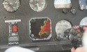
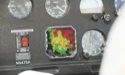
The Sandel unit performed as I expected, very much like its earlier brethren. A small triangle at the bottom of the display represented our helicopter. Black-, green-, yellow- and red-colored graphic patterns represented the various terrain and obstacle heights relative to our heading and altitude. Blue patterns represented bodies of water. In the bottom-right corner of the HeliTAWS unit was a digital radar altimeter.
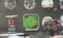
Flying across and down through rough, hilly terrain, containing large transmission towers and spans of powerlines, I quickly discovered stark differences in how each unit performed. The conventional HTAWS generally depicted terrain as large blocky patchworks that I found difficult to interpret. The Sandel unit, on the other hand, depicted the terrain in much finer detail, similar to how terrain might appear on a topographical map.
Encountering large transmission towers or spans of wires, Sandels WireWatch feature took center stage. Not only were the individual towers clearly indicated on the display, but so too were the wire spans, especially highlighted segments that were impending hazards in our aircrafts flight path.
The differences in the way the two units registered, displayed and provided cautions and warnings of impending conflicts was dramatic, as well. The Sandel seemed to instinctively understand how the aircraft was being operated and provided only cautions that were appropriate and timely. When it did alert, with a synthesized voice and a visual indication on the display, the conflict was clearly identified with location and type of hazard relative to the aircraft. Throughout the same flight profile, I felt the conventional HTAWS gave numerous terrain and obstacle alerts that were unwarranted; I ultimately turned the volume down to minimize the distraction.
I found the conventional HTAWS devices handling of visual cautions to be similarly problematic. The display became crowded with numerous indications of what the unit determined to be hazards; however, I did not feel they were specific or clearly defined. Also, when the unit alerted on what it determined as an impending conflict, the terrain data was replaced by a colorful box and the words warning terrain. This screen had to be manually cleared by the pilot before it would return to the terrain following; another distraction…
A Real World Example
So, how good is HeliTAWS from day to day?
In May 2010, North Memorial Air Care (NMAC), which operates seven AgustaWestland AW109s (a mixture of newer Powers and older Agusta A109Cs) at five emergency medical services bases in Minnesota, began a program to upgrade and standardize its avionics to include Garmin 400W and 430W, GPS and GPS/nav/comm units, respectively, plus the Sandel HeliTAWS devices.
Said NMAC chief pilot Shane Johnson, I like having HTAWS in the cockpit, and the Sandel has performed as advertised, with no failures on any of the seven units we have installed in our fleet. He pointed out, Here in the flat lands, rising terrain isnt much of concern in over 90 percent of the area we fly in, but having the obstacle database is a great thing.
He then added: The Sandel is a great tool to increase situational awareness. Beyond having the terrain and obstacle database, it is the display for our radar altimeter, allowing us to get rid of our analog rad-alt gauges that were prone to problems. It also has a clear and bright screen that acts as a secondary moving-map display showing your course line if youre navigating by GPS. In our aircraft with TCAS [traffic alert and collision avoidance systems], the Sandel replaced those displays [too]. (In fact, the ST3400H HeliTAWS can also act as the primary display for traffic advisory systems, traffic alert and collision avoidance devices, and traffic warning systems.)
The ST3400Hs integration into the aircrafts GPS navigation system offers benefits beyond just course following, too. Said Johnson, It has an aural warning system, so you get callouts for terrain, obstacles, reaching your pre-selected altitude, below glideslope and more. Thats nice, because you can keep your eyes out of the cockpit and still benefit from having the system. Also, there is an off-airport mode so you can decrease the sensitivity and not have to listen to all of those warnings when landing at a scene or hospital.
The Round Up
You know what they say about opinions: everybody has one. My observations and conclusions are just that mine and in no way are they an indictment of any particular HTAWS manufacturer. But, as a result of my experiences and research in preparing this article, it has occurred to me that HTAWS units built only to the minimum standards established by the FAA (as per TSO-C194) may be falling terribly short of providing helicopters with the enhanced level of controlled-flight-into-terrain protection that is attainable today.
Sandel, on the other hand, has taken a different approach. Instead of building to the minimum standards, its engineers examined the distinctive characteristics of how and where helicopters operate, so as to better understand what capabilities were important in an HTAWS.
Armed with that information, Sandel then encouraged its engineers to push the boundaries of their creativity and existing technology. They were challenged to exceed their own expectations and preconceived opinions that otherwise might limit innovation. Their goal: to develop a new standard in high-fidelity HTAWS tailored specifically to the unique manner in which helicopters operate.
From my perspective, and those familiar with Sandels ST3400H, the engineers may have actually exceeded their goals the system is a standout in HTAWS technology. One might even go so far as to suggest it shines a brilliant light on what many consider to be weak, outdated HTAWS standards. Either way, Sandels innovative technology is cutting-edge and I believe one day it will become a new standard in the industry.
Dan Megna recently retired after nearly 30 years with one of Southern Californias sheriffs departments. His last 18 years were spent serving in the departments aviation unit, where he logged over 8,000 hours in helicopters as a tactical officer, pilot and flight instructor.